|
|
||

|
|
The map to the left
is an adjustment of the map on the webpage: The map to the right is an Click on
the map to the right, |
|
![]()
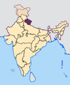
General description of the Area
The Garhwal (west) and Kumaon (east) forms the
mountainous state Uttaranchal. The state Uttaranchal contains a large part of the Indian Himalaya.
The state Uttaranchal is bordered to the north by Tibet and to the east by
Nepal. On the west side it is bordered by the state Himachal Pradesh and on the
south side by the state Uttar Pradesh. Before 2000 it was
the mountainous part of the state Uttar Pradesh. Since November 2000 this part of
Uttar Pradesh has become a separate state, Uttaranchal.
In the Uttaranchal part of the Himalaya there are a lot of large mountains above
6000 m, e.g:
Gauri Parvat (6590 m), Gangotri (6614 m), Panch Chhuli( 6910 m), Nanda Devi
(7816 m),
Nanda Kot (6861 m), Kamet (7756 m), Badrinath (7140 m), Trishul (7120 m), Chaukhamba
(7138 m) and Dunagiri (7066 m).
The mountainous area of Garhwal is the origin of the Gangga and a lot of its tributaries.
One could make some high mountain treks in this region,
e.g. the Gangotri trek to the source of the Bhagirathi (also called the source
of the Gangga), but then you have to be here in the summer season (half May till
the end of september).
General description of the trek
We made this trekking
wit a taxi (with taxi driver) and a guide for five days. The trek was arranged
by Silvia Baratta (Swami Rama Sadakha Grama), in cooperation with us
Detailed description
I have made this trip with Margriet. In
this report I give some information from my Garmin GPS. The information with *
is a minimum distance. Because sometimes contact failure of the GPS apparatus in
the dense woods, the information is not complete. So the walking distances could
be a little more.
Because of the broken down of my camera, the pictures on this webpage have been made
by the camera of Margriet: sometimes the picture has been made by me, sometimes by
Margriet.
Saturday
8 April
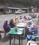
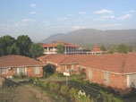
At 7.00 o�clock we
were picked up by the taxi at the reception of the Swama Rama Sadhaka Grama. At
the end of the afternoon we arrived in Okthinath. On the way to Oktinath
we made two little stops on viewpoints. The first viewpoint was before Deoprayag,
where we had an overview of the confluence of the rivers Bhagirathi and
Alaknanda. From that point on the river continues as Gangga. This is also a holy
place with ghats (where one can take rituel dip).
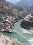 |
Large photo left is 143
Kb
and right 128 Kb Left:
The confluence of the Bhagirathi (left) and the Alaknanda (right) to
Gangga Photo's: Margriet van Kampen |
 |
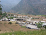
From there we drove through the Mandakini valley
to Oktinath.
 |
The large photo's are
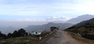
respectively 66 Kb, 143 Kb, 146 Kb and 173 Kb Left:
View
to the north from the guest house in Oktinath through the valley Photo's: Margriet van Kampen |
 |
 |
 |
We slept in the Tourist Rest House
Uktinath in Uktinath (Altitude:1300 meter )
Sunday
9 April
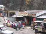
We went by taxi to the marketplace of the village at 1400 meter. There we started our hike.
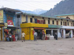 |
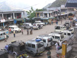
Large photo left is 91
Kb Left: The marketplace of Oktinath Photo: Margriet van Kampen |
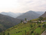
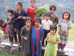
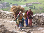
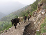
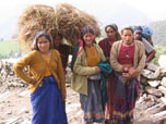
From the market a mountain path, first rather steep, later on more flat, leads us to Lake Deoria Tal. On the way up, we meet several people and animals. We had also nice views on the valley behind us.
 |
The large
photo's are respectively 117 Kb, 165 Kb, 153 Kb and 112 Kb Left
top: Climbing the path, we had a good
view on the village of Oktinath Photo's: Margriet van Kampen |
 |
 |
 |
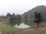
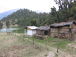
Around 12.45 o'clock we arrived at the lake. On the shore of the lake was a Tea Stall and a few tents, which can be rented.
 |
The large photo's are
respectively 70 Kb, 135 Kb and 94 Kb Left:
View
on Lake Deiria Tal from the tea stall (Photo: Fred Triep) |
 |
 |
Information
about the trip (from my watch and my Garmin GPS)
|
Start trek |
8.55 o�clock. |
1400 meter |
|
Arrival at Lake |
12.45
o�clock. |
2400 meter |
|
Moving time |
1.52 hours |
|
|
Stopped time
(resting and looking around) |
2.09 hours |
|
|
Total time |
3.50 hours |
|
|
Distance |
5,75 km * |
|
The tea stall was
already two weeks in function, in general the tea stall is in function from the
beginning of April till the end of October (precise times depends on the weather
of snow conditions). Denzil told us, that there was a lot of snow
around the lake two weeks ago. Now the surroundings were totally green.
We slept in one of the tents and we used dinner and tea at the the tea stall.
Monday
10 April
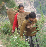
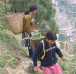
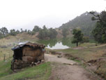
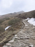
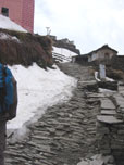
In the morning we went along a very good path from the lake to Sauri. We went on a very easily accessible and curved path, paved with large stones.
 |
The large
photo's are respectively 151 Kb, 127 Kb, 139 Kb and 138 Kb Left
top: We went on a curved path with large stones down to the village
Sauri Photo's: Margriet van Kampen |
 |
 |
 |
Information
about the trip (from my watch and my Garmin GPS)
|
Start trek |
7.45 o�clock. |
2400 meter |
|
Arrival at
Sauri |
8.50 o�clock. |
2000 meter |
|
Moving time |
0.48 hours |
|
|
Stopped time
(resting and looking around) |
0.33 hours |
|
|
Total time |
1.05 hours |
|
|
Distance |
2,1 km * |
|
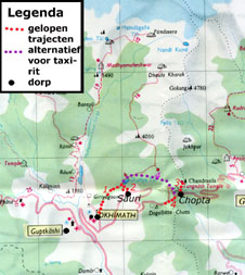
| It is possible to hike directly from Lake Deoria Tal to Chopta instead of using a taxi. We did not use this option, by lack of a porter. It taxes about five hours to hike from the lake to Chopta. This possibility is indicated on the map wit purple points. |
 |
Large photo left is 132
Kb
and right 145 Kb Left:
View from our room at Hotel Raj Mahal on the restaurant of the hotel and
the main street of Chopta Photo's: Fred Triep |
 |
First we hiked to the Tungnath temple through the Rhododendron wood on a well accessible path of stones (from 2900 till 3000 m). Then we hiked up through the open field.
 |
Large photo left is 151
Kb
and right 181 Kb Left:
Entrance gate in the main street of Chopta to the path to the temple
Tungnath Photo's: Fred Triep |
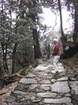 |
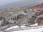
At 3000 meter there are some good flat places to put a tent, but we preferred a stay in the guesthouse.
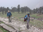 |
The large photo's are
respectively 110 Kb, 119 Kb and 154 Kb Left:
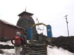
Denzil and Fred going to the temple of
Tungnath, with on the background some good places for camping |
 |
 |
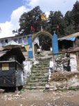
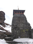
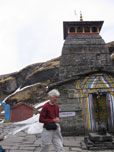
After arriving at the temple, we had tea in one of the houses below. The temple was closed, but opens at half May. It is the highest Shiva temple in India.
 |
 |
The large photo's are
respectively 72 Kb, 82 Kb and 100 Kb Totally
left, left and right: The temple of Tungnath,
still closed in April |
 |
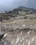
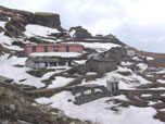
After the tea we took a path up till 3500 meter, where the hiking was troubled by snowfields.
 |
The large photo's are
respectively 121 Kb, 102 Kb and 106 Kb Left
and right: Impressions of the little village around the temple of
Tungnath
|
 |
 |
After that we went down and reached
the hotel just before the thunder was starting.
Information
about the trip (from my watch and my Garmin GPS)
|
Start trek |
11.08 |
2900 meter |
|
Arrival at
temple |
13.08 |
3456 meter |
|
Total time |
2.00 hours |
|
|
Arrival at
highest point |
? |
3500 meter |
|
Arrival at
Chopta |
17.03 |
2900 meter |
|
Total time (to
temple, to snowfields and down to Chopta) |
5.55 hours |
|
|
Total distance |
8 km * |
|
Tuesday
11 April
| Large photo to the right is 149
Kb
Photo: Fred Triep |
 |
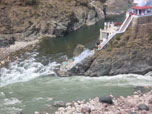
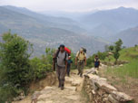
After lunch we put our luggage in the car and while the taxi driver drove the car through all the bends in the road down, we make a shunt along a path down (traject 4 on the map). We reached an old house before the driver�s arrival. From there we went further by car. We drove through Uktinath to Guptakashi (1319 m). The car stopped in the main street.
| Large photo to the right is 124
Kb Right: The main street of Guptakashi, viewed from the stairs to the Vishwanath temple Photo: Fred Triep |
 |
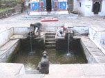
From there we walked up to the very nice
Vishwanath temple with the water bassin before (with water from two underground tributaries
of the Gangga and the Yamuna).
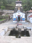 |
Large photo left is 126
Kb
and right 121 Kb Left:
The Vishwanath temple in Guptakashi with the bassin in front of it Photo's: Fred Triep |
 |
After this visit we
went to our accommodation (a bungalow) at Syal Saur in de Mandakini Valley.
Wednesday
12 April
|
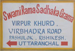
Large photo left is 85
Kb
and right 92 Kb Left:
The announcement of the ashram of SRSG on the Virbhadra Road in
Rishikesh Photo: Fred Triep |
 |
Guide and taxi driver
We
can recommend Denzil as a guide and Mangial as a driver for such a trip. They
are friendly and helpful. Denzil discuss the different options and makes
everything as pleasant as possible for his guests.
Guide: Denzil, (Garhwal Adventures in
Rishikesh)
phone: 0091- 9411381891
email : dreamcatcher747@gmail.com
or hot_denzil@indiatimes.com
email: hemant_43@rediffmail.com
Literature
K.P. Sharma
Garhwal and Kumaon
Cicerone Press, Series: Himalayan Walking and Trekking, 1998
ISBN: 1-85284-264-4
http://www.ciceroneguides.com/acatalog/index.htm
Garry Weare
Trekking in the Indian Himalaya
Lonely Planet, 4 th edition, September 2002
ISBN: 1740590856
http://shop.lonelyplanet.com/product_detail.cfm?productID=2118&
Hugh Swift
Trekking in Pakistan and India
ISBN 0-340-51556-2
Out of print, but otherwise try
http://www.amazon.com/gp/product/0340515562/002-3969539-2044809?n=283155
Maps
India Himalaya Map 7: Garhwal (Uttaranchal)
Folded Map, Scale 1:200 000
Leomann Maps, 2005
ISBN: 0906227917
http://www.mapsworldwide.com/map_10538.htm
or
http://www.manymaps.com/shop/contents/nl/p3299.html
Badari- Kedar
Trekking Map Series, Scale 1:250.000
Survey of India
Links on hiking in the Indian Himalaya
- We are still working on this part
This page has been made new on Monday 11 June
2007.
![]()
For additions or reactions, you can e-mail me:
![]() email : Fred Triep
email : Fred Triep